A trip to Swaledale
During our holiday at Pateley Bridge in Yorkshire some years ago Swaledale was too far north to explore. From Barnard Castle it is easy to reach. Ellen Bowness´s book provided me with excellent information on the various locations. I set off very early, crossed Rutherford Bridge (where I took the photos of the Oyster Catchers during my last stay) and continued towards Tan Hill Inn.
It was very misty and visibility at Tan Hill Inn (Highest Pub in England) was very poor (photo #4).
What weather conditions can be like up there in the winter one can see in this BBC article:
Storm Arwen: Tan Hill Inn guests leave snowed-in pub at last - BBC News
Only when I descended into Swaledale the sun came through and I managed to get some good roadside shots of the retreating mist.
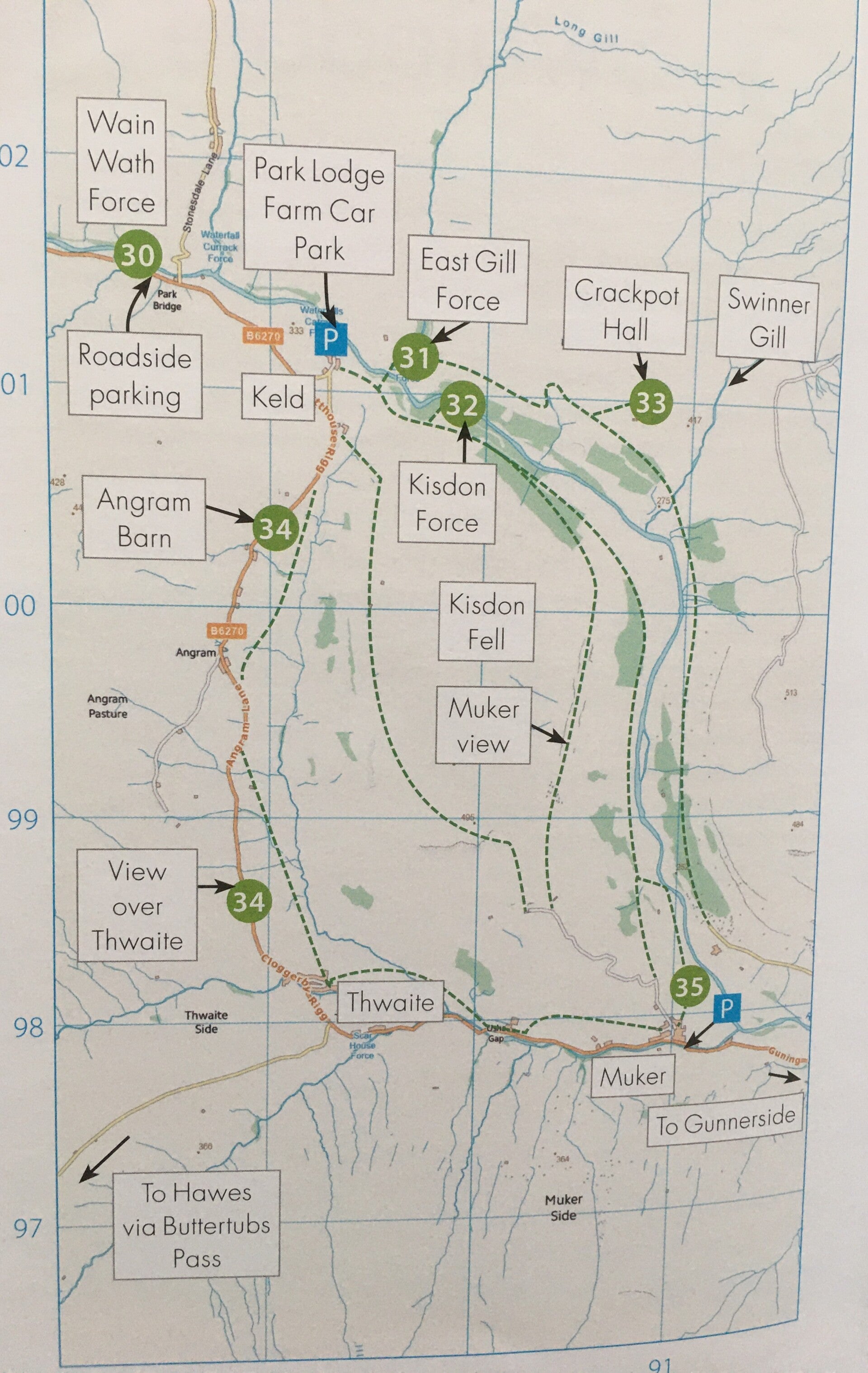
My first stopover was Wain Wath Force just next to the small road that leads down from the Tan Hill Inn. (photo # 10)
The description in the book was once again excellent. I was on my own at the waterfall and had a good start to the day.
From there it is only a short drive to the small Hamlet of Keld where I took the Park Lodge Farm Car Park as base for my next excursions. Park Lodge Campsite | Camping in Glorious Swaledale (rukins-keld.co.uk)
Instead of doing one long walk I did three excursions from there to East Gill Force; Kisdon Force and finally Crackpot Hall. It meant doing some the first bit of the route three times but I had the Farm as a base to return to and change my photo gear and have rests in between. For the close by waterfalls I needed the heavy tripod and on the longer walk to Crackpot Hall I only had the camera with me. Plus when the small farm shop / restaurant opened later on I got some nice coffee and cake there on top of my packed lunch I took with me. Altogether I spent 5 hours there and really enjoyed the fantastic scenery.
East Gill (a tributary to the river Swale) Force has a beautiful upper fall (photos # 11 and 12) and a smaller lower fall that cascades into the River Swale (photos #15 and 16) with some good scenery in between (photos # 13 and 14).
The climb down to Kisdon Force was really difficult but well worth it. It is in a steep gorge and has a smaller upper Fall and a bigger lower fall which was particularly difficult to get to photos # 17 - 20. On the way back up I took some photos of the scenery on this steep climb back to the path that brings you to the parking lot again photos #21 - 27. The Barn on the photos is Myers Bottom Barn, the very one featured on the information board at the car park.
After a good rest I started my third and longest walk towards Crackpot Hall. Photo #28 is looking down at Kisdon Force deep down in the ravine at the beginning of the walk. By the time I reached Crackpot Hall it was lunch time and the light wasn´t very favourable for photos but I still enjoyed the fantastic views from that vantage point with Crackpot Hall as a great landmark (photos #29 - 32). The final shot is #33 taken from the small bridge that leads across the Swale at East Gill and shows the East Gill entering the Swale.
By the time I left Keld it was already quite busy particular with Motorcycles but also a lot of cars. I continued to the next Photo spot listed in the book which are some barns at Angram. Again I spent a lot of time there taking various photos of the fantastic scenery with the barns as foreground and Thwaite in the background (photos # 34 - 43. Some are converted into Black & White which is equally nice I think).
My intention was to have a stopover in Thwaite and Muker but I was already quite tired and both towns were really congested with lots of tourists. So I decided to go to my last destination of the day which are the Old Gang & Surrender Smelt Mills on the way back towards Barnard Castle.
Surrender Smelt Mill is just across the small car park (photo # 44). As you can see it was glorious sunshine in the afternoon which wasn´t ideal for the ruins of the Smelt Mill. A more moody weather would have given a much better atmosphere. I was warned from the info in the book that the walk to Old Gang Mill was quite long. I started off nevertheless on a very rough track. After 10 minutes I noticed it would take far too long by foot. The barrier at the beginning of the track that leads off the main road towards the mill had been open. So I decided to go back and drive up to the mill. When I came back I met a jogger who just came back to his car. He offered to stay until I was back so that the barrier wouldn´t be shut while I was up at the mill. Again the photos are not ideal in this picture postcard weather ((photos # 45 - 47 (#45 is looking back towards the car park from the walk.)) therefore it is definitely a place to come back to in different weather conditions.
I continued towards Langthwaite and completed the huge loop I did that day. While I took photos at the top of the hill of the view towards Langthwaite with the road leading back up again towards Barnard Castle (photo # 48) I noticed some grouse in the heather nearby and was able to get a few shots.
Finally before I descended towards Barnard Castle the clear weather gave me the chance to take a good shot of Barnard Castle in the distance with the Bowes Museum as a landmark. Remarkable because 10 hours earlier the visibility up on that hillside had been close to zero in dense fog.
A tiring but fantastic day in Swaledale thanks to Ellen Bowes excellent book.